 Researchers at the U.S. Army’s Communications-Electronic Research, Development and Engineering Center are working on a new technology that troops could soon be using to locate IEDs reports Todd South of the Navy Times. The new technology uses virtual reality (VR) goggles and/or tablets to paint a digital picture of what lies beneath the ground. This creates a virtual map of the ground for explosive ordinance disposal (EOD) specialists. The research could eventually lead to robots equipped with these new sensors.
Troops hunting hidden bombs or IEDs by hand often rely on upgraded metal detectors or a version of that technology strapped to a ground robot. They must sweep the areas at a near-uniform speed and pattern and listen carefully for the right tone to sound to know if something is under the sand or in that pile of trash.
Researchers at the Army’s Communications-Electronics Research, Development and Engineering Center are in initial stages of developing technology that will allow troops to strap on virtual reality goggles or monitor a tablet screen to see where the sensor detects a threat.
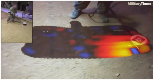
The novel handheld mine detection recently on display at CERDEC’s testing center in Fort Belvoir, Virginia included a soldier waving the detector over sand and the sensor then “painting” a digital picture on a nearby screen of what lies beneath the sand lane.
“This gives us the opportunity to see signatures in the ground without taking away situational awareness,” said Sgt. 1st Class Jared Huffstickler, a combat engineer who is assigned to the counter mine division of CERDEC’s Night Vision and Electronic Sensors Directorate, to help test new bomb detection gear.
Chris Marshall, a scientist at the countermine division, said the larger goals of the project are to merge a variety of detection devices into one. Currently soldiers must use different sensors for different threats. But another aim of the program is to provide better information to bomb techs and distance them even farther from the threat.
The technologies they are developing can be added to existing detectors and are “modular” so they can also be put on robotic detectors from ground robots to, potentially, aerial drones.
The digital image that comes on screen is color-coded; darker colors from black to blue mean nothing’s there while brighter reds and yellows show a potential threat.
But the information doesn’t stop at the color swath. The system can help capture the shape of the object and with the correct algorithms, kick in radar technologies that can then define the shape of the object, Marshall said.
“The radar can show the shape of a mine instead of a circle and the soldier can use that information to determine if it is a threat, something that needs to be remedied,” Marshall said.
The system receiving all the data can also monitor the position of the mine detector and geolocate threats.
Sgt. 1st Class Clint Farrell, assigned to CERDEC, told attendees that once geolocated and data such as shape and size are gathered, that information can then be shared in the network so any bomb tech coming upon the area would have it at their disposal.
This creates a virtual map of the ground in that area – a bomb tech’s dream for navigating threats.
“So, imagine walking down the road with a heads-up goggle. You don’t see dirt, you see everything your counterpart has done up there so you basically come, ready to go, in a couple of minutes,” Marshall said.
It’s far off from what many in the explosive ordnance disposal field have seen for much of their careers – sticks with rags tied to them marking potential threats that they or their robots must then inspect.
Watch the demo video here.


